May 20, 2025 / Survey / 2 min read
RTK and PPK: Survey Grade Accuracy From the Air
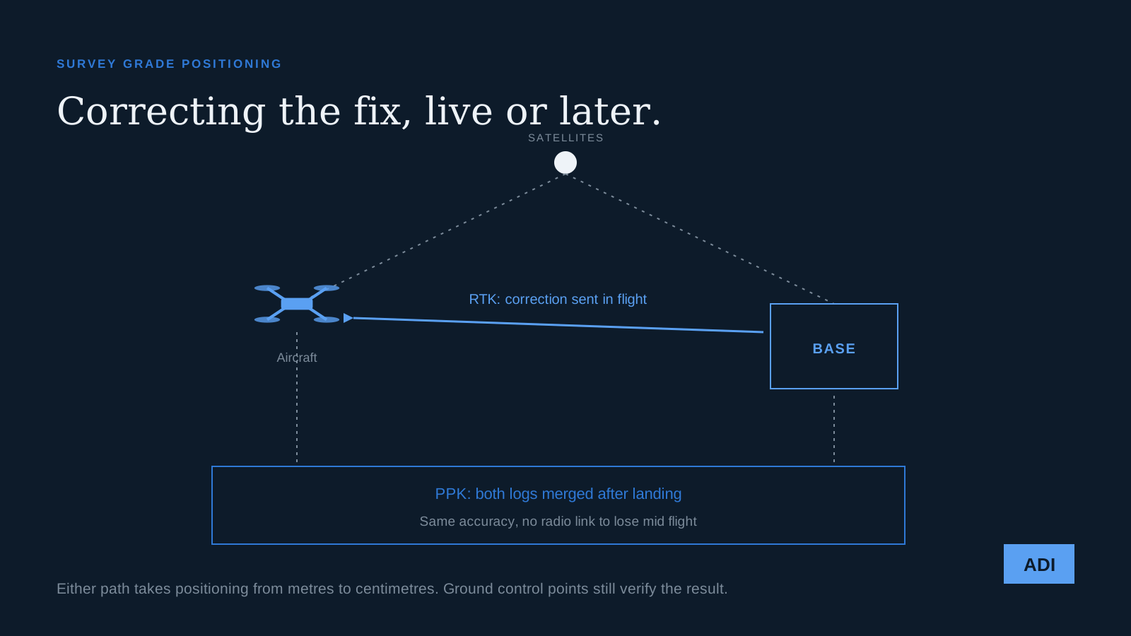
A standard satellite fix is accurate to a couple of metres. For finding a restaurant that is fine. For a site model where a contractor will calculate earthworks, it is useless, and the fix is one of two techniques that most survey oriented drone work now uses as standard.
Why the raw fix is not enough
Satellite positioning is a timing calculation, and the timing is corrupted on the way down. The signal slows unpredictably through the ionosphere and the troposphere, satellite clocks drift, and orbits are known only approximately. The errors are largely the same for two receivers close together, which is the insight both techniques exploit.
RTK
Real Time Kinematic uses a base station on a known point. The base compares where the satellites say it is with where it actually is, and broadcasts the difference to the aircraft over a radio or network link. The aircraft applies the correction as it flies and records positions already fixed to centimetre level.
You get corrected data immediately, which is useful when someone needs an answer today. The cost is dependence on that link. If the radio drops out behind a building or the cellular connection stutters, the corrections stop and the aircraft quietly reverts to a rough fix for that part of the flight.
PPK
Post Processed Kinematic collects the same information and does the maths later. The aircraft logs raw satellite observations, the base logs its own, and after landing the two are merged in software to produce corrected positions for every image.
There is no live link to lose, which makes it more robust in exactly the environments where the link is fragile: dense urban sites, tree cover, anywhere with poor cellular service. The tradeoff is that you cannot see whether the data is good until you process it, so the field discipline has to be right.
Neither replaces ground control
This is the misconception worth correcting. Both techniques fix where the camera was when each photograph was taken, with great precision. They do not verify the resulting model against the ground.
Surveyed ground control points still matter, because they are the independent check. Most of our survey work uses corrected positioning plus a small number of control points, some used in the processing and some held back purely to measure the error in the finished model. Without that check you have a number and no evidence for it.
We wrote about the control point side of this in ground control points and photogrammetry.
When it is worth paying for
Earthwork volumes, where a small vertical error across a large area becomes a lot of money. Sites being flown repeatedly over months, where each flight has to align with the last one. Anything feeding a design model, or anything a surveyor will certify. Corridor work along a road or a utility line.
When is it not worth it. Marketing imagery. Progress photography. Roof condition surveys. Anything where the deliverable is a picture rather than a measurement. Paying for survey grade positioning on a job that produces a video is spending money on a number nobody will read.
Tell us what the data has to prove and we will tell you which of these you need, and when the honest answer is neither. Start with the deliverable.